Back in 1851, the Mormon Station was the only permanent settlement a traveler could expect to find in the part of the country that is now Nevada. Once a small piece of the sprawling Utah Territory, Carson Valley was an important stop for those seeking fortune or a better life on their way to California. Renamed Genoa in 1856, the town built a post office and several other buildings which allowed them to officially lay their claim to the title of “Nevada’s First Town”. Thanks to Nevada’s State Historic Preservation Office and Carson Valley’s rich history, we have a driving tour you won’t want to miss. Check out the full list of roadside Historic Markers with this Google Map list.
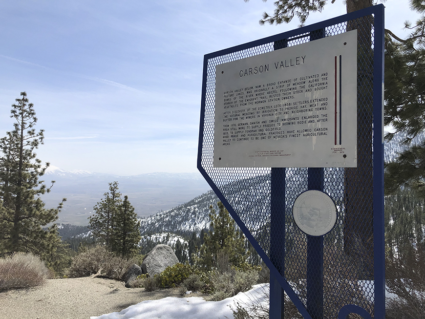 Carson Valley, now a broad expanse of cultivated and pasture lands, was originally a strip of meadow along the banks of the river where 49’ers, following the California branch of the Emigrant Trail, rested their stock and bought vegetables from the Mormon Station owners.
After the discovery of the Comstock Lode (1858) settlers extended the natural meadows by irrigation to provide hay, meat, and butter for the miners in Virginia City and neighboring towns.
Starting in 1870, German, Danish, and Swiss immigrants enlarged the area again to supply produce to booming Bodie and, after 1905, to supply Tonopah and Goldfield.
Good range and agricultural practices have allowed Carson Valley to continue to be one of Nevada’s finest agricultural areas.
The remains of Cradlebaugh Bridge, built in 1861, by William Cradlebaugh, stand ¼ mile west of here. This bridge shortened the distance from Carson City to Aurora in the then-booming Esmeralda Mining District. There were two routes from Carson City south to the bridge where they joined, crossed the river, and headed into the desert. One followed the west side of the Carson River. The foothill alternate went via Jacks Valley and the old John James Ranch, then around the hill to the bridge. Five miles south of Cradlebaugh Bridge the road passed Desert Station, a lively hostelry, and beyond, the Twelve Mile House en route to Esmeralda.
The road and bridge were purchased by Douglas County in 1895 for $5,000.
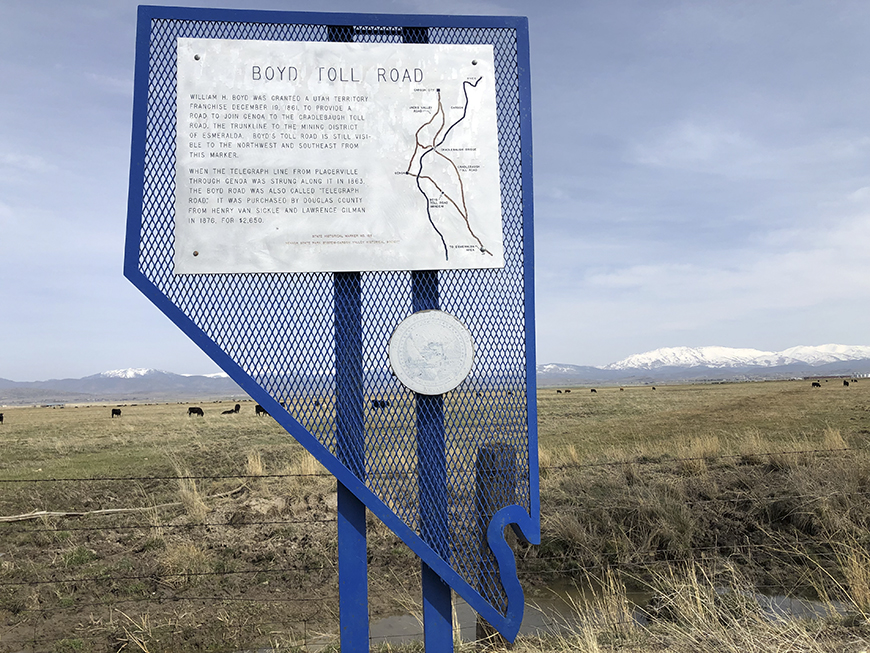
William H. Boyd was granted a Utah Territory franchise December 19, 1861 to provide a road to join Genoa to the Cradlebaugh toll road, the trunkline to the mining district of Esmeralda. Boyd’s toll road is still visible to the northwest and southeast from this marker.
When the telegraph line from Placerville through Genoa was strung along it in 1863, the Boyd Road was also called “Telegraph Road.” It was purchased by Douglas County from Henry Van Sickle and Lawrence Gilman in 1876 for $2,650.
Double Springs, also known as Round Tent Ranch or Spragues, was a station on the road through the south end of the Pine Nut Mountains located at a pair of nearby springs. The road provided access between Carson and Walker valleys, both ranching and dairy regions in western Nevada, Double Springs also saw many travelers on their way to Esmeralda County. At one time, a toll road ran from this area west to the Kingsbury Road that still connects to Lake Tahoe.
About four miles north along the highway is the former location of Mammoth Ledge, also known as Carter’s Station. That site served as the post office for the Eagle Mining District, and the polling place in 1861 of the Mammoth Precinct of Douglas County. Stations like these provided water, supplies, and rest for travelers prior to the popularization of the automobile.
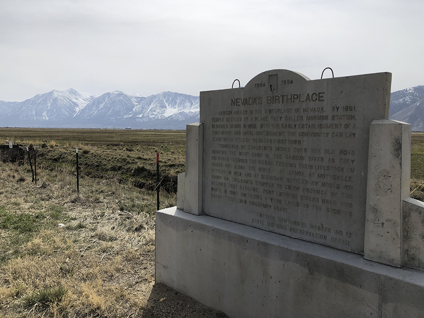
Carson Valley is the Birthplace of Nevada. By 1851, people settled at a place they called Mormon Station, renamed Genoa in 1856. With the early establishment of a post office and local government, the community can lay claim to the title of “Nevada’s First Town”.
Thousands of emigrants moved over the old road skirting the west bank of the Carson River they prepared to cross the Sierra, feeding their livestock on grass cut along the river. At Genoa; at Mottsville, settled in 1852; and at Sheridan, settled by Moses Job about ’54; emigrants stopped to enjoy produce from the region’s first gardens. Pony Express riders used this route in 1860, switching a year later to the shorter Daggett Trail, now Kingsbury Grade.
In 1917 State Senator William F. Dressler gave this 40-acre tract to the Washoe Indians, then living on ranches in Carson Valley. After a school was opened in 1924, it became a nucleus of settlement.
Before the intrusion of European Americans in the 1850s, Washoes spent the winter in the Pinenut Hills, where they stored autumn harvested pinenuts. In summer, they lived in the Lake Tahoe Basin, fishing the tributary streams and gathering roots and berries. In fall, they hunted rabbits and gathered seeds in Carson Valley.
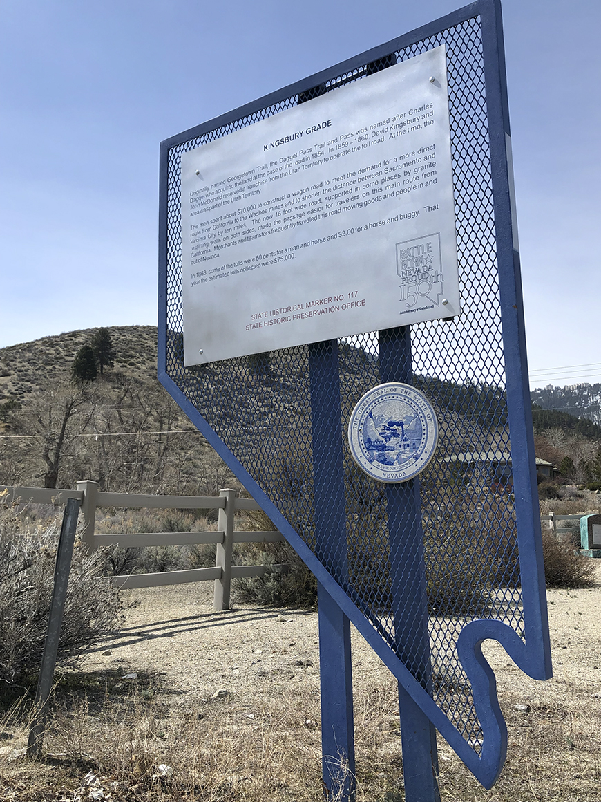 Originally named Georgetown Trail, the Dagget Pass Trail and Pass was named after Charles Dagget who acquired the land at the base of the road in 1854. In 1859-1980, David Kingsbury and John McDonald received a franchise from the Utah Territory to operate the toll road. At the time, the area was part of the Utah Territory.
The men spent about $70,000 to construct a wagon road to meet the demand for a more direct route from California to the Washoe mines and to shorten the distance between Sacramento and Virginia City by ten miles. The new 16-foot wide road, supported in some places by granite retaining walls on both sides, made the passage easier for travelers on this main route from California. Merchants and teamsters frequently traveled this road moving goods and people in and out of Nevada.
In 1863, some of the tolls were 50 cents for a man and horse and $2.00 for a horse and buggy. That year the estimated tolls collected were $75,000.
Twelve Mile House was an important stop on the road to the Esmeralda mining camp of Aurora. Mile houses like this one were critical places for rest and supplies along early western road systems before railroads made most mile houses and stations obsolete. Twelve Mile House was part of a network of similar stations that ran from Genoa to Aurora, including another station on the eastern side of the Pine Nut Mountains called Double Springs.
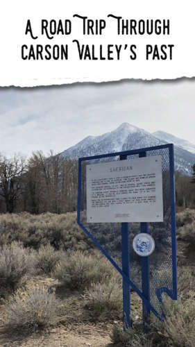
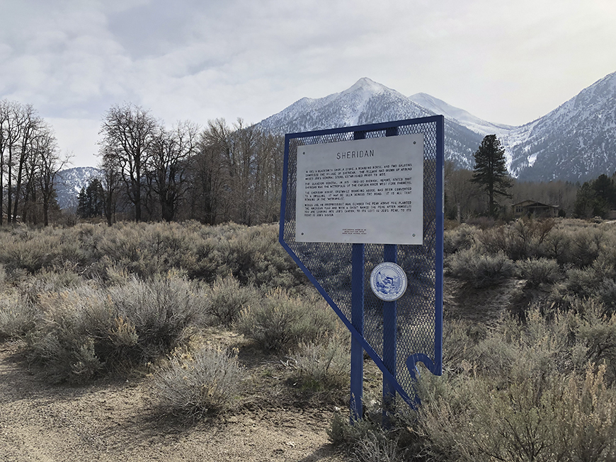 In 1861, a blacksmith shop, a store, a boarding house, and two saloons comprised the village of Sheridan. The village had grown up around Moses Job’s general store, established prior to 1855. The Surveyor General, in his 1889-90 biennial report, stated that Sheridan was the metropolis of the Carson River West Fork farmers. The Sheridan House, erstwhile boarding abode, has been converted to a dwelling. It may be seen across the road. It’s all that remains of the “metropolis.”
Moses Job, an irrepressible man, climbed the peak above this location, planted the American flag and with a shout named the peak after himself. Job’s Canyon is above, and to its left is Job’s Peak. To its right is Job’s Sister.
Early Gardnerville served the farming community and teamsters who hauled local produce to booming Bodie. The first buildings were a blacksmith shop, a saloon, and the Gardnerville hotel. The latter was moved by Lawrence Gilman in 1879 from the emigrant trail between Genoa and Walley’s Hot Springs, where it was known as Kent house, to this site, the homestead of John M. Gardner.
Just as Genoa was the center for British (largely Mormon) settlers after 1851, so Gardnerville, after 1879, became the center for 1,870 Danish immigrants, who founded the Valhalla Society in 1885 and met in Valhalla Hall, one block south.
Starting in 1898, Spanish and French Basque shepherds tended some 13,000 sheep in Carson Valley, which increased to 25,000 by 1925, when the Basques began acquiring their own sheep and land. After 1918, several Basques in Gardnerville opened inns which flourished during Prohibition in the 1920s.
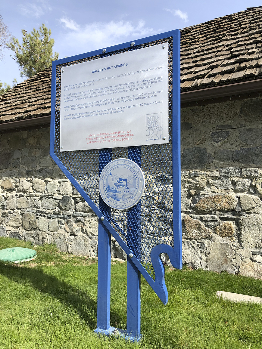 Like many Nevada hot springs, the ones located at Walley’s Hot Springs dot a fault break along which the mountains rise.
In 1862, along the Carson branch of the emigrant trail, David and Harriet Walley developed a $100,000 spa, eleven beds, a ballroom, and gardens. The thermal water (l36 to 160 degrees F) became well known as a cure for “rheumatism and scrofulous afflictions.”
Walley’s Hot Springs sold for a mere $5,000 in 1896, but operated until 1935 when it burned down. Its formal cool cellar was integrated into the complex during a 1970s renovation.
In 1962, trial hydrothermal power holes were drilled here as deep as 1,250 feet and found thermal water with a maximum temperature of 181 degrees.
Minden, the seat of Douglas County since 1916, was named for a town in Westphalia, Germany, where the founder of H.F. Dangberg Land and Livestock Company, was born in 1829. The company established Minden in 1905 to provide terminal facilities for the Virginia and Truckee Railway, which was then extending a branch line southward from Carson City. The passenger and freight depot was situated at this point.
Principal promoter of the town, and its related development was H.F. Dangberg Jr., secretary of the company and son of the founder.
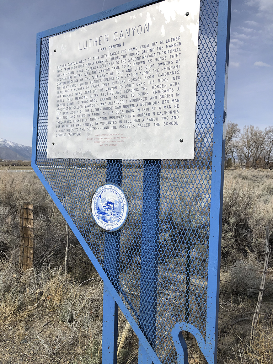 Luther Canyon, west of this site, takes its name from Ira M. Luther, who from 1858-1865 had a sawmill there. The house behind the marker was his home. In 1861, he was a delegate to the second Nevada Territorial Legislature. After 1865, the canyon came to be known as Horse Thief Canyon, because of the “business” of John and Lute Olds, owners of the next ranch south. Besides operating a station along the Emigrant Trail for a number of years, they rustled horses from emigrants. The animals were sent up the canyon to drift over the ridge into Horse Thief meadows. After resting and feeding the horses, they were driven down to Woodfords Canyon to sell to other emigrants. A prospector called Sawtooth was allegedly murdered and buried in the barn south of the Luther house. Sam Brown, a notorious bad man, was shot and killed in front of the Olds barn in 1861 by a man he threatened. “Lucky Bill” Thorington, implicated in a murder in California for which he was hanged by vigilantes in 1858, had a ranch two and a half miles to the south.
We invite you to explore Carson Valley and it’s four towns on your own. For information on things to do and see, click here. Feeling social? Use #WhyCV to connect with @VisitCarsonValley. See you soon!